போவோமா ஊர்கோலம் பூலோகம் எங்கெங்கும்....
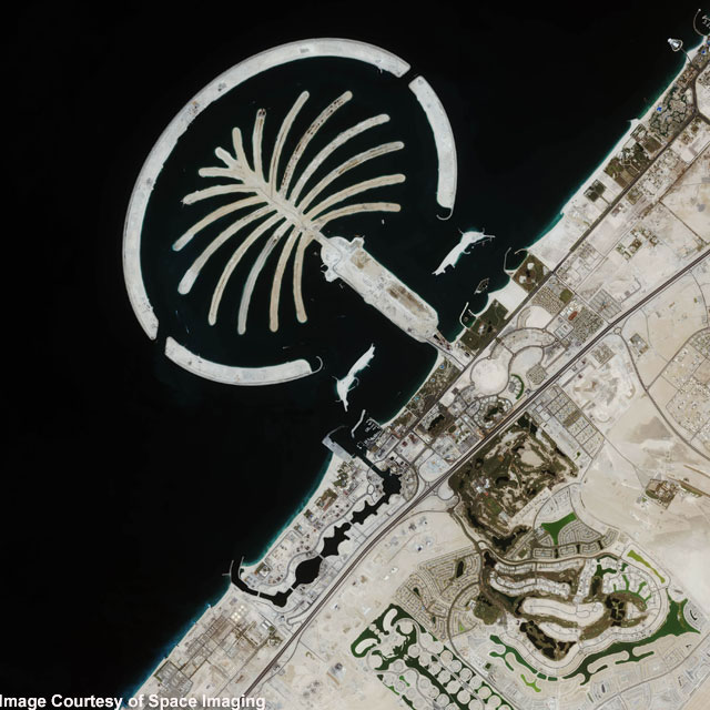 COAST OF DUBAI:
This IKONOS satellite image was collected on July 16, 2004 . The image shows this man-made island that lies off the coast of Dubai in the Persian Gulf . The island is being built from 80 million cubic meters of land dredged from the approach channel to the Emirate's Jebel Ali Port. When complete, this resort will have approximately 1,200 single-family and 600 multi-family residences, an aquatic theme park, shopping centers, cinemas and more.
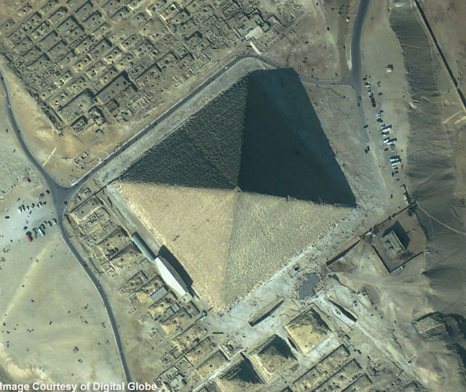 The Great Pyramid, Giza , Egypt:
This featured image is a 61-centimeter pan-sharpened image of the Great Pyramid in Giza , Egypt , collected by QuickBird on February 2, 2002 . The Great Pyramid is estimated to have been built circa 2650 B.C., and was erected as a tomb for the Egyptian pharaoh Khufu of the Fourth Dynasty. Upon the completion of its construction, the Great Pyramid stood 145.75 meters (481 feet) high, and over the millennia has lost approximately 10 meters (30 feet) off the top. It stood as the tallest structure on Earth for more than 43 centuries.
 Niagara Falls
 The image shows the Niagara River that connects Lake Erie to Lake Ontario , snaking around Goat Island , in the lower left of the full image. Most of the river's water plummets over the Canadian/Horseshoe Falls, but some diverted water spills over American Falls and Bridal Veil Falls downstream. Every second, more than two million liters of water plunges over the Horsehoe Falls segment of Niagara Falls creating one of the world's largest waterfalls as well as eating away as much as two meters of rock per year. The image was acquired August 2, 2004
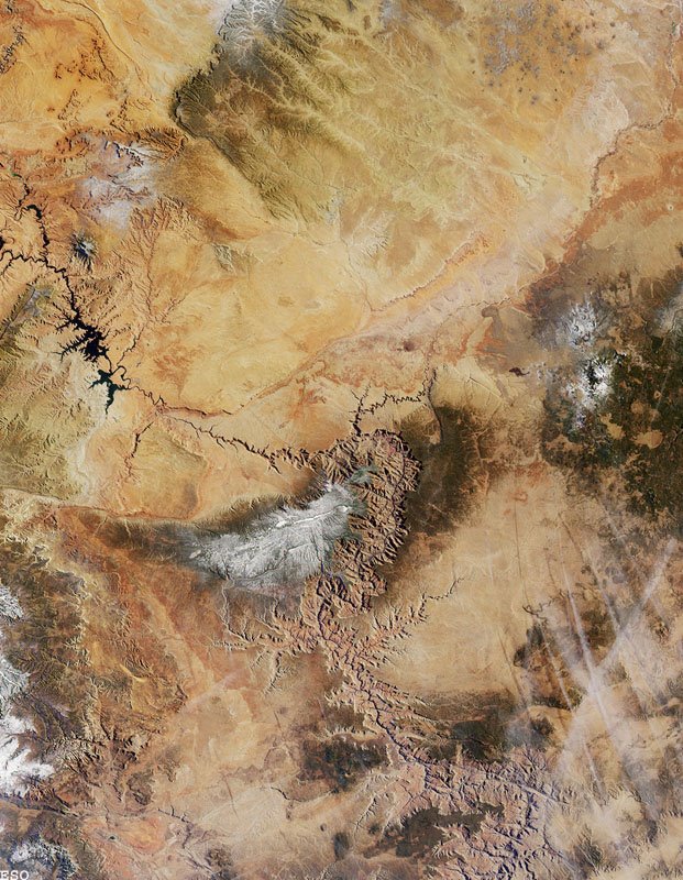 Grand Canyon
Northern Arizona and the Grand Canyon are captured in this pair of Multi-angle Imaging Spectroradiometer (MISR) images from December 31, 2000 . The above image is a true color view from the nadir (vertical) camera. In addition to the Grand Canyon itself, which is visible in the western (lower) half of the images, other landmarks include Lake Powell, on the left, and Humphreys Peak and Sunset Crater National Monument on the right. Meteor Crater appears as a small dark depression with a brighter rim, and is just visible along the upper right-hand edge.
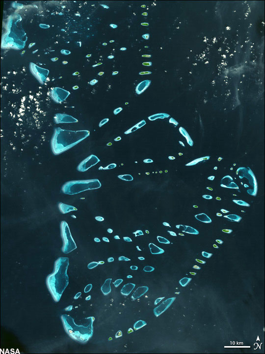 Malosmadulu Atolls, Maldives
 North and South Malosmadulu Atolls are in the Maldives, an island republic in the northern Indian Ocean , southwest of India . The Maldives are made up of a chain of 1,192 small coral islands, which are grouped into clusters of atolls. It has a total area of 298 square kilometers and a population of about 330,000. The capital and largest city is Male, with a population of about 80,000.. Arguably the lowest-lying country in the world, the average elevation is just 1 meter above sea level. The natural-color ASTER image of the Malosmadulu Atolls was acquired on December 22, 2002 , and is centered near 5.3 degrees North latitude, 73.9 degrees West longitude.
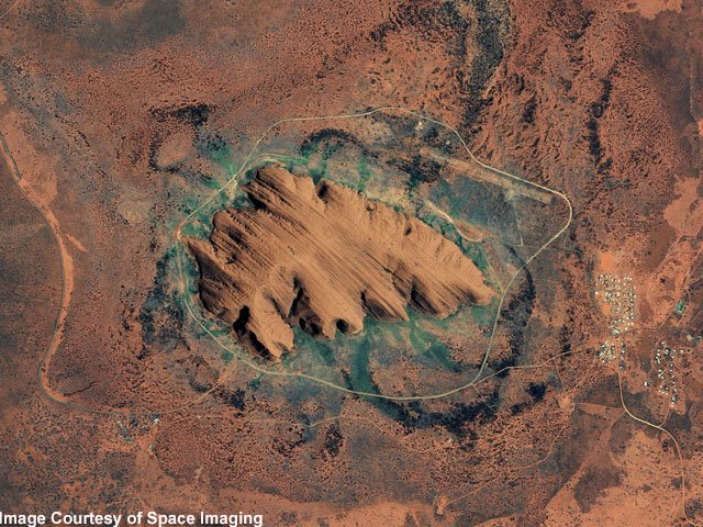 Ayers Rock (Uluru), Australia
 This IKONOS satellite image of Ayers Rock was collected Jan. 17, 2004 . Ayers Rock is located in Kata Tjuta National Park , 280 miles (450km) southwest of Alice Springs , Australia . It is the world's largest monolith, an Aboriginal sacred site and Australia's most famous natural landmark.
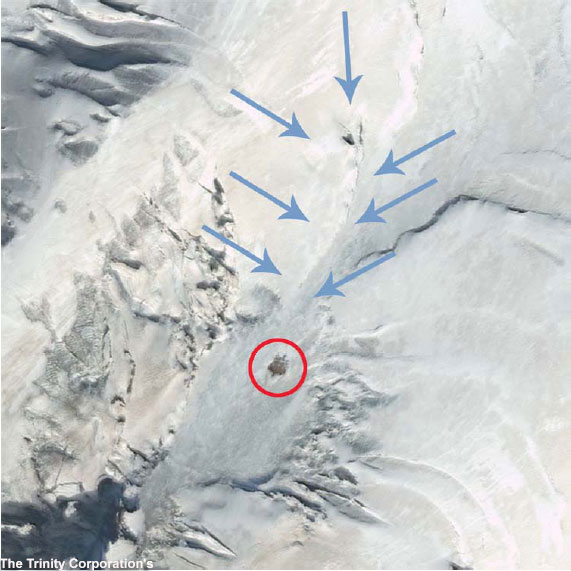 Noah's Ark Site?
 Is it or isn't it? Satellite images of Mt. Ararat , Turkey have pointed to a possible sighting of Noah's Ark. Decide for yourself! Compare this image taken by Digital Globe on September 10, 2003 with Shamrock -- The Trinity Corporation's image (enlarge). Also, note their image is flipped.
 The Nile River
 This image of the northern portion of the Nile River was captured by the Multi-angle Imaging Spectroradiometer's (MISR's) nadir camera on January 30, 2001 . Against the barren desert of northeastern Africa, the fertile valley of the Nile River runs northward through Egypt. The city of Cairo can be seen as a gray smudge right where the river widens into its broad fan-shaped delta. Other cities are dotted across the green landscape, giving it a speckled appearance. Where the Nile empties into the Mediterranean Sea (top) the waters are swirling with color, likely a mixture of sediment, organic matter, and possibly marine plant life. Farther west, the bright blue color of the water is likely less-organically rich sediment, perhaps sand.
 Earth's City Lights
 This image of Earth's city lights, captured on October 19, 2000 , was created with data from the Defense Meteorological Satellite Program (DMSP) Operational Linescan System (OLS). The brightest areas of the Earth are the most urbanized, but not necessarily the most populated. Cities tend to grow along coastlines and transportation networks. The United States interstate highway system appears as a lattice connecting the brighter dots of city centers. In Russia , the Trans-Siberian railroad is a thin line stretching from Moscow through the center of Asia to Vladivostok. The Nile River, from the Aswan Dam to the Mediterranean Sea, is another bright thread through an otherwise dark region.
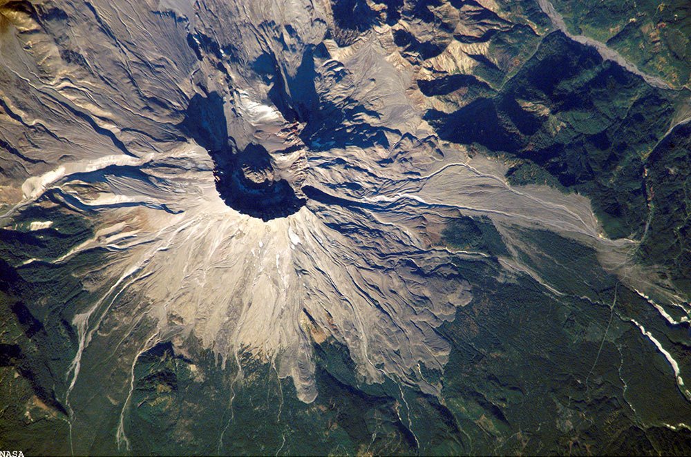 Mount St. Helens, Washington
On a Space Station expedition, astronauts observed and captured this detailed image of the volcano's summit caldera. In the center of the crater sits a lava dome that is 876 feet above the crater floor and is about 3,500 feet in diameter. The dome began to form after the May 18, 1980 eruption of Mount Saint Helens . After the eruption, there was not any dome building eruptions for more than a decade. Afternoon lighting accents the flow features in the volcanic and debris flows and the steep valleys eroded into the loosely consolidated material near the summit. This picture was taken on October 25, 2002 .
 மன்னிக்கவும்... கடைசியில் ஒரு சோகம்...
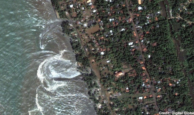
Tsunami strikes the coast of Sri Lanka
This is a natural color, 60-centimeter (2-foot) high-resolution QuickBird satellite image featuring the southwestern coast of Sri Lanka. Imagery was collected on December 26, 2004 at 10:20 a.m. local time, slightly less than four hours after the 6:28 a.m. (local Sri Lanka time) earthquake and shortly after the moment of tsunami impact.
இதுவும் சோகமே..
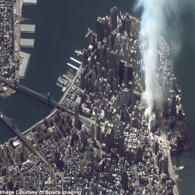
Ground Zero, New York City
This one-meter resolution satellite image of Manhattan , New York was collected at 11:43 a.m. EDT on Sept. 12, 2001 by Space Imaging's IKONOS satellite. The image shows an area of white and gray-colored dust and smoke at the location where the 1,350-foot towers of the World Trade Center once stood. Since all airplanes were grounded over the U.S. after the attack, IKONOS was the only commercial high-resolution camera that could take an overhead image at the time.
posted by Sivabalan at 7/20/2006 09:37:00 PM
![]()
![]()


30 Comments:
படங்கள் தெளிவாக இருக்கிறது !
முதல் படம்
கேமரா ஊசிக் கண்ணில் விழுந்த அரேபிய ஒட்டகம் !
இரண்டாவது படம்
எகிப்தியரின் சாகா சதுர்வேதம் !
மூன்றாவது படம்
நயக்ரா - ஒரு அந்நிய தேசத்து ஆகாய கங்கை !
நான்காவது படம்
மன்ஹாட்டன் - இரு கால்களை இழந்தாலும் நம்பிக்கைகள் ஆயிரங்களில் வின்னோக்கி !
மத்த படங்கள் அதிகம் பார்த்தது இல்லை.
கடைசிப் படம்
சீறீலங்கா கடற்கறை - இதன் அழகை
ரசிப்பதற்கு வந்த அலைகள் அரைநிமிடத்தில் ருசித்துப் பார்த்த துப்பிய சோகம் !
தலைப்பும் அருமையாக கொடுத்திருக்கிறீர்கள் !
Siva,
Started reading, though, I have not finished it all the way.
1) Coast of Dubai = is a sheer idiocy (Man made another sand castle :-)
2) the Great Pyramid = a fabulous piece for their time, simply amazing!
3) Niagara Falls = there is no word to explain its beauty and its mightiness. The falling fumigant sort of water particles itself drenched me even when I was away like 200 ft.
4) Grand Canyon = It coule be spellbounding, one of the most wanted place to visit in my list, yet to visit.
More later... thanks for placing everything under a single page.
கோவி.கண்ணன் அய்யா,
ஆகாய கங்கையை நேரில் கண்டதுன்டா? Just அறிய ஆவல்..
Earth's City Lights படத்தை பார்த்தீர்களா?
வருகைக்கு நன்றி.
//ஆகாய கங்கையை நேரில் கண்டதுன்டா? Just அறிய ஆவல்..
Earth's City Lights படத்தை பார்த்தீர்களா?
வருகைக்கு நன்றி.//
சிவபாலன்...
சிங்கப்பூர், மலேசியா, சிறீலங்கா, நம் இந்தியா தவிர வேறு எங்கும் சென்றதில்லை...செல்லவேண்டும் என்ற ஆவல் உண்டு... பார்போம் :))
Siva,
About Maldives...
//The Maldives are made up of a chain of 1,192 small coral islands, which are grouped into clusters of atolls. It has a total area of 298 square kilometers and a population of about 330,000. //
Look at that, how small area it is and how many people are living in there. On top of it, a bad combination too, the beautiful coral reefs Vs human population :-(
Beautiful white sandy beaches all around so I heard... Love to visit there, the Sechelles Islands, Madagascar etc., one day but when!
நேசி
Grand Canyon & Maldives சீக்கிரமே சென்று ஒரு பதிவை உங்கள் ஸ்டைலில் போட்டுவிடுங்கள்...
நிச்சயம் படிக்க ஆவலாக உள்ளது.
துபாய் பார்த்தீர்களா? அடிச்சு கலக்கிறாங்க...
ஆனால். இயற்கை நேசியான நீங்கள் விரும்புவீர்களா என தெரியவில்லை..
கோவி.கண்ணன் அய்யா,
உங்களை பொருத்த வரையில் மற்ற இடங்கள் ஒன்றும் பெரிய விசயமில்லை..
எனினும் நீங்கள் சீக்கிரமே பார்க்க வாழ்த்துக்கள்..
ஆனால் நான் பார்க்க ஏங்கும் இடம் சிங்கப்பூர்தான்...
சிவபாலன்,
படங்கள் அருமை. நீங்கள் குறிப்பிட்ட இடங்களில் இதுவரை மூன்று இடங்களுக்குத்தான் சென்றிருக்கிறேன்.
[1]Niagara Falls
[2]Tsunami strikes the coast of Sri Lanka
[3]Ground Zero, New York City
நியுயோர்க நகரில் இருந்த உலக வர்த்தக மையக் கட்டிடங்களில்[உச்சியில்] நான் எடுத்த படங்களை
மிகவும் கவனமாக வைத்திருக்கிறேன்.
வெற்றி,
நயகரா நீர்வீழ்ச்சி அருமை..
நான் செல்ல விரும்பும் இடங்களில் இலங்கையும் ஒன்று.. நம் சகோதரர்களின் வெற்றியை பொருத்து இது சாத்தியம்..
// நியுயோர்க நகரில் இருந்த உலக வர்த்தக மையக் கட்டிடங்களில்[உச்சியில்] நான் எடுத்த படங்களை //
நீங்கள் பாதுகாத்து வைத்திருக்கும் படங்கள் வெளியிட கூடியவை எனில் தயவு கூர்ந்து தனிப் பதிவாக கொடுத்தால், நான் இப்பதிவுடன் இனைக்துக் கொள்வேன்.
நிச்சயம் உபயோகமாக இருக்கும்.
வருகைக்கு நன்றி.
//It is the world's largest monolith, an Aboriginal sacred site and Australia's most famous natural landmark.//
Sounds an interesting place to keep on our eye.
//color, likely a mixture of sediment, organic matter, and possibly marine plant life. //
Wonders of Nature! In the middle of desert there we have a running river, how interesting that could be. Imagine having lost in the desert for a couple days and you accidentally run into this huge river with crystal clear water, how could have been your experience. Amazing.
சிவபாலன்,
/* நீங்கள் பாதுகாத்து வைத்திருக்கும் படங்கள் வெளியிட கூடியவை எனில் தயவு கூர்ந்து தனிப் பதிவாக கொடுத்தால், நான் இப்பதிவுடன் இனைக்துக் கொள்வேன்.
நிச்சயம் உபயோகமாக இருக்கும். */
நிச்சயமாக அனுப்புகிறேன்.
வெற்றி
மிக்க நன்றி.
Theka,
Your narration about nature is excellent.
Your comment really makes me feel good.
Thanks
Earth's City Lights
இந்த புகைப்படம் பல முறை பார்த்ததுண்டு.. எனக்கு இப்புகைபடத்தில் மிகப் பெரிய சந்தேகம் உண்டு...
1)பூமியை satellite மூலம் படம் பிடித்தால்.. இப்படி முழு உலகம் தட்டையாக மேப் போல் தெரியாது... பூமி பந்தின் ஒரு பாகத்தை மட்டுமே ப்டம் பிடிக்க முடியும்...
2) எந்த நிமிடத்திலும், பூமியின் பாதி பகலாகவும், மீதி இரவாகவும் தான் இருக்கும்.. அப்படியிருக்க எப்படி முழு உலகமும் இரவாய் இருப்பது போல் படம் பிடிக்க முடியும்...
யாராவது என் சந்தேகத்தை தீர்த்து வையுங்களேன்...
//Is it or isn't it? Satellite images of Mt. Ararat , Turkey have pointed to a possible sighting of Noah's Ark. Decide for yourself!//
Noah's Ark, another man's fantazy creation, for that a subsequent evidence through the satelite picture makes the rest of the wonders' pictures a questionalbe.
//The brightest areas of the Earth are the most urbanized, but not necessarily the most populated.//
Another one of the most undesirable activities is on the earth; the light pollution, put us our mental stability at stake by constantly exposing to the light. In due course, we are losing so much of the cosmic consciouness of losing the night sky for the light, the by product is restlessness and insomnia.
The only place we can get hooked up with the dark sky is now in the remotest part of India and in Africa. Now it is a laxuary seeking out of places for star gazing, where you have less light pollution.
I have seen that picture in National Geography, it is scary. India is also lighting up.
நக்கீரன்
வருகைக்கு நன்றி.
நான் இப்பொழுதுதான் முதல் முறையாக இப்படத்தை பார்கிறேன்.
நீங்கள் கேட்கும் கேள்விக்கு பதில் தெரியவில்லை.
யாரேனும் பதில் சொல்வார்கள் என நினைக்கிறேன்.
Nakeeran
the answer is in your question itself.
they will take the picture at different time zone and put them altogether.
Just like the atlas map!
Theka,
//was created with data from the Defense Meteorological Satellite Program (DMSP) Operational Linescan System (OLS).//
You are right.
//After the eruption, there was not any dome building eruptions for more than a decade.//
I take these volcano's points for a "reminder" of mother nature's other side of angry face.
She is still beautiful only in the outer layer by cooling down, and that too having drenched for miilions of years of rainfall in the course of making of earth. So the core of our earth is still angry, any time it can *sigh* through her blisters so called
the "volcano's eye points."
Amazing, amazing! Who are we to stop?
Nesi,
I request you to put a Tamil Blog based on this blog. It must be very interesting, I believe.
I am very much eager to read.
So please...
//I request you to put a Tamil Blog based on this blog. It must be very interesting, I believe.//
you mean, do you want me to share some of the facts and my own thoughts on each one of these as i do now?
Hmmm... good idea, we will see what we can do. Thanks though. :-) I am almost there heading to Atlanta...
Nesi,
Yes. I mean in your own way in Tamil about all these photos mentioned here.
You can use any photo or anything in this blog. I will be very happy.
Thanks.
//Tsunami strikes the coast of Sri Lanka
This is a natural color, 60-centimeter (2-foot) high-resolution QuickBird satellite image featuring the southwestern coast of Sri Lanka. //
இந்த சுனாமி வந்த நேரத்திலே எனக்கு நிறையெ கோபம் இந்த அறிவியல் நுட்பத்தின் மேலே. என்ன இருந்து என்ன பிரயோசனம், மேலே சாட்டிலைட் அனுப்பி பூமிய ஃபோட்டோ பிடிக்கிறோம், ஆனா ஆயிரக் கணக்கிலெ மக்கள் சாகப் போற விசயம் ரொண்டு மூணு மணி நேரத்திக்கு மேலும் ஒருத்தருக்கு ஒருத்தர் தொடர்பு கொள்ள அத்துனை நேரமிருந்தும், நம்மால் அதனை செய்து கொள்ள முடியவில்லை.
கண்கொட்ட பின்னே எதற்கு சூரிய நமஸ்காரம் என்பது போல்தான் எனக்கு இந்த அத்தனை தொழில் நுட்பமும் எனக்குப் பட்டது.
இல்லெ "poor illeterate idiots" செத்து ஒழியட்டுமின்னு வளர்ந்த நாடுகள் கண்டு கொள்ளமல் விட்டு விட்டார்களா?
There is lot more to talk about this ignorance and negligence of the world scientific community.
தெகா
சுனாமியைப் பற்றிய உங்கள் கருத்து உணமைதான் என எனக்கு தோன்றுகிறது..
நன்றி.
aliscia,
Thanks for your visit.
சிவபாலன், அழகான சேகரிப்பு!
நக்கீரன், "GIS/Satellite image processing" என்னும் டெக்னாலஜி மூலமாக வெவ்வேறு நேரங்களில் பிடிக்கப்பட்ட படங்கள் "Collage" போல கோர்க்கப்பட்டு, மனித கண்களுக்கு புரியும்படியாக "Global Map" முறையில் வழங்கப்படுகிறது - அப்படி வந்தது தான் அந்த இரவொளிப் படம்.
GOOGLE EARTH FREE FULL VERSION AVAILABLE CRACKED , on
www.bitlord.com
Madura,
வருகைக்கும் கருத்துக்கும் நன்றி.
mobilemob,
Thanks for your visit.
மகேந்திரன்,
வருகைக்கும் கருத்துக்கும் நன்றி.
Post a Comment
<< Home